The original plan was to leave the rally when it closed on Sunday and motor southward to Virginia and West Virginia for a meander-fest of motorcycle fun bathed by late July azure skies and warmed by the summer sun. Hah!
Jeff and Mary Ackerman and I met up at our usual I-70 exit stop at the appointed time, then slabbed it on the interstate for the entire first day on our way to the BMW Riders Association Rally, this year in Wellsboro, Pennsylvania. After snoozing in a cheap motel in Akron, Ohio, we twisted the throttle on interstate again for the first few hours of the second day. Wow, I really would like to have cruise control for times like this. Jeff and Mary both have this convenience and, I admit, I was appropriately jealous of the techno-wizardry that would somewhat mitigate the hum drum of the concrete treadmill we were on.
I was left to relying on popping Altoid mints to smack my tongue awake with a slap of cinnamon. Unfortunately, my clumsy gloved hand lost its grip on the little red metal tin as I pulled it from the pouch on my tank bag. When something falls from your moving motorcycle, the first reaction is to haul it down to a stop and then run back, facing traffic, to retrieve the item before it gets pancaked by an 18 wheeler.
In this case, this idea was only a flash before more rational thoughts overrode this silly notion. The mints would certainly be spread over a wide expanse of gravel-strewn road shoulder at best, and rendered inedible. I did slightly mourn the loss of the small, flip top tin which fit so well in the back pouch of my tank bag; but, that could hopefully be replaced at the snack counter at the next gas stop.
Shortly before crossing the Ohio/Pennsylvania border, we side-stepped the interstate and rolled onto pavement more befitting a motorcycle excursion. No need to rely on mints for stimulation; the scenery and the smooth two-lanes were entertainment enough. We swooshed along nicely until early afternoon when Jeff pulled over for our Dairy Bar break. This is an activity that we try to slip into our trips whenever there is a convenient and appropriate facility along the way. Upstate Pennsylvania has a plethora of family run ice cream joints from which to chose and a very nice one presented itself at just the right time.
Now, Plan Two emerges. While waiting for our frosty treats, we found a rack with a motorcycle touring map covering the area around our rally stop. The maps said “free,” the perfect price for a couple of two-wheeled tightwads. During our ice cream cone taste-bud tango, we hatched an alternative travel plan. Mary would leave us on Sunday morning, because golf is now her life and she needed to return for yet another link related activity, and then Jeff and I would check into a local motel to spend the rest of the day exploring some of the yummy looking routes on the map. We would simply delay our migration to Virginia by one day.
As per typical BMW motorcycle rally protocol, upon arrival we found a nice, partially shaded spot where we erected and pegged down our temporary living quarters. Jay Green showed up a bit later and nestled in next to our newly created neighborhood. We filled the coolers with magic elixir and settled into our camp chairs ready to enjoy rally living for a few pleasant days.
We went on a couple of day trip excursions, took a train ride, sampled local brews and cuisine, attended some rally programs, checked out the beer tent, and chatted with the usual rally suspects about the usual rally topics. We visited the so called Grand Canyon of Pennsylvania. I thought it was a “nice valley.” but certainly not a “grand canyon.” However, I will allow the locals their hyperbole in support of their tourism industry. Life was mighty good.
However, Saturday afternoon the skies started to darken, and the wind turned Messenger of Doom as it shifted and picked up in speed. A look at the radar display on my I-Phone confirmed the meaning of these omens – a storm was approaching. Checking the weather app, it became clear that there would be rain starting late afternoon and continuing to mid-morning on Sunday. That meant packing wet gear. Arrggh!
The rain came down steadily all afternoon and throughout the night. Rain while camping is not all that bad as long as the tent is dry, you are warm, your air mattress stays inflated, and you have a “relief bottle” for recycled beer handy, all of which were thankfully the case.
Sunday morning dawned to overcast skies and an intermittent drizzle. Saturated tents got wrung out as much as possible before cramming the wet mess into carry sacks that we would be unable to dry out until arriving back home in an estimated two weeks. Yuk.
Mary said goodbye and rode off on her Can Am Spyder with the goal of meeting her tee time the next day. By doing so, she missed The Tree. She took some of her and Jeff’s wet camping gear; I simply tightened down the straps on my carry bag and watched rivulets of water squeeze out from the corners and run down onto my bucket shaped seat. How delightful. Jay took off for Pittsburgh to visit relatives, thereby also avoiding The Tree. Jeff and I implemented Plan Two.
Although gray and cloudy, the drizzle stopped as Jeff in the lead, and I in trail, picked up damp, but drying, blacktop. One would prefer sunny skies, but “not actively raining” was quite acceptable, and even pleasant, for the moment. We headed west on a looping route that would lead us around and back to a Wellsboro motel for the evening before picking up our earlier planned route south. Despite wearing the rain suit, it was starting to be a nice, maybe even a very nice, ride. The previous storm left puddles here and there, and leaves and small branches on and around the road. I was quite comfortable following the scenic route 320.
Then, I saw Jeff’s left turn signal come on, followed by a course change down Stony Fork Road. A glance at my GPS showed this to be a U shaped route which, if followed, would take us back around to route 320 in a few miles. I was unsure of Jeff’s motivation, however the rural Pennsylvania scenery was nice and the pace leisurely. At just about the apex of the U, I could see Jeff slow a bit as he seemed to eye a gravel road on our left. To my relief, he let it pass and continued on the paved, Stony Fork Road that curved around ahead of us.
Let me set the record straight concerning unpaved roads. I am not necessarily against them. I owned a couple of dirt oriented bikes and made a sincere effort to break into the so called Adventure Ride genre of motorcycling. I’ve had some good and not so good experiences on both gravel roads and actual trails. Honest truth, I was never very good at off-road riding, and it always scared me a bit because physical contact of a body and a pile of rocks can really hurt, depending on the velocity and trajectory of the falling, and now out of control, rider. I am also keenly aware that a functioning motorcycle is my ride home. A vehicle with a tree branch stuck up its tank, or with a bent wheel or broken shift lever is not likely to provide me with reliable transportation. I don’t want to argue that I am now too old for this kind of adventure, but, let’s phrase it thusly: I have outgrown the need to participate in the activity.
And so, Jeff continued around the bend to end up back on the route we had come from earlier. When he made a right turn which would point us back in the direction we started, I wondered what he was thinking. When he made another right turn again placing us on Stony Fork Road, from which we had just exited, I smiled slightly, thinking that he had just made a simple mistake in navigation which he was sure to notice soon.
We passed several buildings that we had just ridden by a mere ten minutes ago. I was amazed that Jeff apparently did not recognize the familiar landmarks and expected him to turn around. We continued on. And then, we approached the gravel road on our left. I held my breath slightly and, yes, yes he did it. He turned down the ominous portal, identified on the slightly bent sign post as, “Rattlesnake Road.”
Why would you do that? Do you not think that “Rattlesnake Road” was named that for a reason? For that matter, why visit “Dead Man’s Gulch,” “Hell’s Canyon,” or “Devil Mountain?” Later, Jeff explained that the road looked fairly short on the map and directly connected with a state route in the area where we wanted to be. Logic be damned, read and heed the sign, I say.
Pennsylvania gravel is not quite like Missouri gravel. The rocks are black, kind of like coal.The gravel is small in size, kind of like crushed coal. The surface, at least when wet, is slick, kind of like wet coal. Remember, it rained heavily all night.The surface was black, and it was slick. Jeff did not stop to talk to me about his decision. I was sure he could feel the heat from my burning eyes penetrating the back of his helmet.
We started out with a medium grade uphill stretch. This was not too bad. There were no deep ruts and the surface was pretty well packed. I could feel that it was a bit slippery, so I was careful to go easy on the throttle and to force myself to release the death grip on the handlebars and let the bike feel its own way. I tried to stay off the center hump of the road, but had to cross over from track to track at times to avoid spots that appeared rutted or pot holed. I was feeling OK about the feel of the bike and doing fine with reading and reacting to the surface – this was going to work out.
Then, the road came to a Y junction. I was happy to see Rattlesnake Road bend around to the right. I was not happy to see a “No Outlet” sign on Rattlesnake Road and Jeff lean around to the left fork. I said Rattlesnake Road wasn’t too bad; well whatever the spur was that we took made Rattlesnake Road look inviting. This road was obviously not as well traveled, or at least not as well maintained as the old snake. It was much more deeply rutted in the tracks and the center hump resembled a ski slope. I checked my GPS, and sure enough, the road would connect with a nicely paved state route in about three miles. At this point it was probably more treacherous to try a turn around and head back than to just soldier on.
The road continued to narrow and the trees closed in. About a mile further on, I saw Jeff’s rear tire do a figure S. He caught it and remained upright. I was mildly amused until my rear tire did exactly the same thing within mere seconds. Fortunately, I reflexively reacted and the bike stayed the course. A close one, indeed. Although mildly shaken at the near disaster, I was actually gaining some confidence that the ordeal would soon be over and that I would actually live through it. Then, as I carefully eased around a slick corner, there it was – The Tree.
Recall that I don’t like gravel roads. Recall that the road is narrow, slick and rutted. Recall that I almost lost it a mile back. Recall that we are five miles into a six mile road with the promise of actual pavement at the end. Now picture a tree, about three feet in diameter lying across the path. Now picture me strangling Jeff with a bungee cord.
Obviously, the tree had been uprooted during the recent storm, and no one, at least no one with a chain saw, had been down that road since. It was too large and heavy for us to move; my pocket knife would not have been a serious threat to removal. The road surface was so uneven and slippery that it took me several minutes to carefully use my short little legs to awkwardly maneuver the bike to a spot where I could safely extend the side stand. There was a bank, about seven feet high on the left where the exposed root ball was obvious. The tree stretched from this point at about a 45 degree angle to rest on the right side of the road, forming a triangle.
Our choices were limited. We could wait until someone with a chain saw came along. Not an unreasonable plan for this part of the country, and, it was Sunday – church going day. A local person might randomly come along in a few minutes, or a few hours, or not at all. We could also, with great care, help each other turn their bikes around and go back the way we came. Certainly possible, but, I was not doing a happy dance over the prospect.
There was another option. The left side of the road was flanked by a drainage ditch that dipped down from the road bed. It was full of high weeds. Considering the rain, it would certainly be muddy and soft. However, putting our bikes in that ditch might get them down low enough to pass under the highest point of the right triangle tree. It just might work.
However, the bikes were loaded with camping gear and full side panniers. It would take both of us to push the machines through the opening without putting one over on its side. My F700, being smaller and lighter, was more likely to make it than Jeff’s 1200 GS, so we started with his. If we could not get his bike through, then we would both turn around and bite the long, muddy bullet to backtrack to pavement.
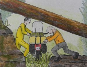
I took the right side of the GS1200, Jeff took the left. We walked his bike up to the opening. By leaning the bike to the left, the top of his windshield just cleared the rough bark obstacle and we squeaked through the opening. My bike was relatively easy to get through the same way.
The rest of the day was certainly anticlimactic after the tree incident. We returned to our motel and checked the weather forecast for the rest of the planned trip. According to the Weather Channel on our room TV, there was a strong high pressure off the Atlantic coast and the jet stream swooped all the way down to the Gulf coast then back up to Maine. That meant the entire eastern part of the country would be solid rain for at least the next several days. Time to activate Plan Three.